Map Area Calculator
Draw a polygon or rectangle on the map to calculate surface area. Click on the map to start placing points or switch tools on the top right.
Discard current drawing?
You have an unfinished shape in progress. Switching tools will discard the current temporary geometry.
The Map Area Calculator lets you measure the size of any area by drawing a polygon or rectangle directly on an interactive map. Trace the edges of a yard, field, parking lot, or lake, and the tool calculates the enclosed area in acres, square feet, square meters, hectares, square miles, and square kilometers. It's useful for estimating lot size before buying property, planning fencing or sod, checking field acreage, or measuring natural areas. Everything runs in your browser, so there's nothing to install and no account to create.
How to Measure Area on a Map
1. Find Your Location
Type a street address, city, park name, or ZIP code into the search bar above the map, or click Locateto center on your GPS position. Switch between Road and Satellite in the top-right layers button, and zoom in as closely as possible around your target property.
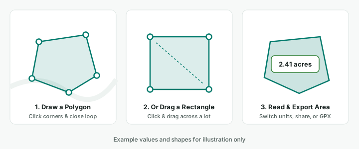
2. Draw a Polygon or Rectangle
The map opens in Polygon mode by default—click (or tap) each corner around the perimeter, then click the first point, double-click the last point, or click Finish to close the shape. For square or rectangular lots, select the Rectangle button on the top-right map toolbar and click and drag across the parcel. Use Undo to remove the last point or shape, or Clear Allto reset the map.
3. Edit or Refine the Boundary
Select any completed shape on the map or in the Shapes list, then click the Editicon on the map toolbar to drag corners, click dashed edge midpoints to insert extra points on curved boundaries, resize rectangle sides, or drag the center handle to reposition the shape. Area and perimeter update live as you edit.
4. Switch Units, Copy, Share, or Download GPX
Choose your preferred unit under Units (ac, ft², m²,ha, mi², or km²) to update the total area and map labels immediately. You can click Copy Area, generate a Share link that preserves your drawn shapes, or click Download GPX to export the boundary for GPS apps and GIS tools.
What Can You Measure with a Map Area Calculator?
Residential Properties and Land Lots
Homeowners often want to know how much yard they have before ordering sod, seed, mulch, or fertilizer, which are usually priced per square foot or per 1,000 sq ft. Tracing the lot, then subtracting the house footprint and driveway, gives a quick working number. Buyers can also compare a listing's advertised lot size with what they see on the map.
Farmland and Agricultural Fields
Farmers measure fields to plan seeding rates, fertilizer and chemical applications, and expected yield, all of which are typically calculated per acre. Tracing each field separately, rather than the whole parcel, keeps waterways, roads, and wooded strips out of your planting total.
Commercial and Industrial Properties
Contractors and facility managers use area measurements for early-stage estimates: square footage of a parking lot for sealcoating or restriping, a flat roof for coating, or a site's paved versus landscaped area. These quick takeoffs help scope a job before a site visit.
Parks and Recreational Areas
Planners, HOAs, and sports leagues measure park space, playing fields, trail loops, and open lawns to plan maintenance, mowing schedules, or event layouts. Area is also a common way to compare green space between neighborhoods.
Lakes and Natural Areas
Pond and lake owners need surface acreage to dose treatments and stock fish correctly. Trace the shoreline with closely spaced points, and remember that water levels change seasonally, so the visible shoreline may not match current conditions. The same approach works for wetlands, woodlots, and conservation areas.
How Does Map Area Calculation Work?
Every point you place on the map is stored as a pair of geographic coordinates: latitude(north–south position) and longitude (east–west position), measured in degrees. Connecting those points in order creates a closed polygon; when you draw a rectangle, dragging creates a four-corner polygon aligned to those north–south and east–west coordinates. You can see the exact coordinates of any spot with theLatitude Longitude Finder.
The catch is that degrees aren't a fixed distance. One degree of latitude is roughly 69 miles everywhere, but one degree of longitude shrinks from about 69 miles at the equator to zero at the poles. On top of that, web maps use the Web Mercator projection, which stretches shapes more the farther they are from the equator. If you measured a polygon by counting screen pixels, a field in Minnesota would look larger than an identical field in Texas.
To avoid that distortion, MapCalc doesn't measure the flat picture. It calculates area directly from the vertex coordinates using Turf.js geodesic geometry (a spherical Earth model), accounting for Earth's curvature. The result is a real-world area in square meters, which is then converted into the selected unit—for example, a square lot measuring roughly 208.7 ft × 208.7 ft equals 4,046.86 m², or 1 acre (43,560 ft²). For continent-scale areas, results from a spherical model can differ slightly from ellipsoidal calculations used in specialized survey GIS software.
Understanding Map Measurement Units
| Unit | Equivalent |
|---|---|
| 1 Acre (ac) | 43,560 square feet (4,046.856 m²) |
| 1 Hectare (ha) | 10,000 square meters (≈ 2.47105 acres) |
| 1 Square Mile (mi²) | 640 acres (≈ 2.58999 km²) |
| 1 Square Kilometer (km²) | 1,000,000 square meters (100 hectares) |
- Acres (ac) are the standard for land in the United States: real estate listings, farmland, and rural parcels. For conversions from lot dimensions, try the Acreage Calculator.
- Square feet (ft²) are used for smaller spaces such as residential lots, buildings, driveways, and landscaping materials.
- Square meters (m²) are the metric base unit, common in engineering, international projects, and most countries outside the U.S.
- Hectares (ha) are the metric equivalent of acres, used for agriculture, forestry, and land records internationally.
- Square miles (mi²) describe large areas like townships, counties, lakes, and city limits. A standard U.S. survey section is one square mile.
- Square kilometers (km²) are the metric unit for large regions, watersheds, forests, parks, and municipal boundaries.
Map Area Measurements vs. Official Land Records
It's common for your traced area to differ from the acreage on a deed or tax record. Here's why.
Property Boundary Accuracy
Property lines aren't visible on aerial imagery. Fences, hedges, and mowing lines often sit a few feet off the true boundary, and some lots include easements or right-of-way along the road. When you trace what you see, you're estimating where the line is.
Map Image Resolution
At lower zoom levels, each screen pixel can represent several feet on the ground, so small click errors add up over a long perimeter. Imagery can also be slightly misaligned or captured years ago, before new construction or clearing.
Professional Land Surveying
A licensed surveyor locates physical monuments, researches deeds and plats, and measures with precision instruments. Their results are what title companies, lenders, and courts rely on, and no online tool replaces that process.
Geographic Calculation Methods
Recorded acreage may have been calculated decades ago, with different methods, or rounded. Some records list gross acreage including road right-of-way; others list net usable acreage. Small differences in method can produce different totals for the same land.
Is a Map Area Calculator Accurate?
The math behind the calculation is reliable; the result is only as good as the outline you draw. These factors have the biggest impact:
- Point placement: Zoom in close and click exactly on the corners. A point placed a few feet off on every corner of a large lot can shift the total noticeably.
- Number of vertices: Straight-sided lots need only their corners, but curved shorelines and winding fence lines need many points. Too few points cut corners off curves.
- Map data quality: Base map detail varies by region. Rural areas may have less precise features than cities.
- Calculation method: A spherical geodesic model is well suited to everyday land measurement, but it is a model, and specialized survey software may use more detailed ones.
- Imagery limitations: Shadows, tree canopy, and image age can hide the true edge of a property or field.
Online measurements are a good fit for estimating materials, comparing properties, planning projects, and sanity-checking listings. They aren't appropriate when a legal or financial decision depends on the exact number. If you need the perimeter or straight-line lengths of a boundary, use theMap Distance Calculator.
Frequently Asked Questions
How do I calculate the area of land on a map?▼
Can I measure irregular land boundaries?▼
How do I calculate acres from a map?▼
Can I measure land area using satellite imagery?▼
What units does the map area calculator support?▼
Can I calculate the area of a property?▼
Is this map area calculator free?▼
Can I use the map area calculator on my phone?▼
Are online map area measurements legally accurate?▼
Related Calculators & Tools
Calculate land acreage from dimensions or measure directly on an interactive map.
Measure straight-line or multi-point path distances across geographic terrain.
Click any location on the map to find its precise GPS coordinates.
Online GeoJSON viewer to map and inspect your files. Upload or paste GeoJSON and instantly visualize points, lines, polygons, and properties.
